From Vermont to California, we found routes that will take you close to the sights, sounds and scenery surrounding U.S. rivers, lakes and reservoirs.
Late-day sunlight bounced off the rapids in the river below. The water sang different notes as it splashed up and over rocks. As I cycled along the riverside path, heading downstream just like the current, the flowing water and the route it carved over eons along the valley floor presented an ever-changing landscape.
Biking waterside adds many elements to a ride: scenery, bird-watching, wildlife viewing and fall leaf peeping. You might bring along a collapsible fishing rod for an angling session or a bathing suit for a dip.
My recent ride was on a section of the Rio Grande Trail in Colorado, a 42-mile former rail bed turned cyclist and pedestrian route than runs along the Roaring Fork River between Aspen and Glenwood Springs. Here are five other waterside routes to consider.
COLORADO
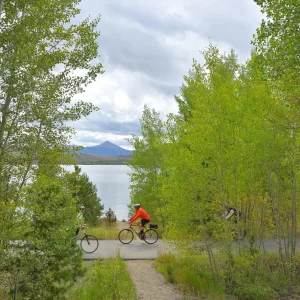
Dillon Reservoir, Summit County
A highlight of biking the 18.7-mile paved route that circles this high-altitude reservoir in central Colorado is viewing the soaring peaks that ring the area: the rounded Buffalo Mountain and other summits of the Gore Range; the necklaced ridgeline of the Tenmile Range; and Grays and Torreys, two of Colorado’s famed 14ers (peaks higher than 14,000 feet).
Decades ago, the original town of Dillon lay where the 3,233-acre reservoir is now. Opened in 1963, the reservoir captures water in the Blue River for use in the Denver area.
There are many entry points with parking. Head out early to encounter fewer cyclists, dog walkers, joggers and the occasional unicyclist on the well-marked path that makes up most of the route. You may pass anglers casting in coves and paddle boarders plying the morning waters. Ride counterclockwise to tackle the 500-foot climb up Swan Mountain Road along the path’s switchbacks; at the top, consider hiking the 0.6-mile loop to Sapphire Point Overlook before the exhilarating descent along the road’s shoulder.
Near Frisco, the route, partly on a boardwalk, passes through a wetland. Shortly before the dam’s west side the path winds through fragrant lodgepole pines and by several inlets; a spur leads to a viewing scope for ospreys and other birds.
VERMONT
Island Line Trail, Lake Champlain
This 13.4-mile rail bed turned trail near Burlington, Vt., not only hugs the shore of Lake Champlain for much of its length, but also takes cyclists across the water on the narrow, three-mile-long Colchester Causeway. “It’s the coolest part of the ride,” said Peggy Shinn, a Vermont-based sportswriter. “You feel like you’re riding on top of the lake.” On a clear day, Ms. Shinn added, you can see all the way from Mount Mansfield in the Green Mountains to Whiteface Mountain in the Adirondacks.
Originally a route along the Rutland Railroad, which served Vermont and northern New York until 1961, the pedestrian and bike trail replaced the tracks in segments starting in 1990.
From south to north, the route begins on what’s also called the Burlington Bike Path at Oakledge Park (check out the Stonehenge-like earth clock, both a sundial and a compass). With Lake Champlain glistening to the west, you’ll pass marinas, parks and beaches. At Mile 7, cross the mouth of the Winooski River on a bike-and-pedestrian bridge. A well-marked trail section then leads through quiet residential roads in Colchester before it turns to crushed gravel and approaches the shore.
About three-quarters of the way down the causeway, a 200-foot break known as the Cut allows boats to pass through. To continue to the trail’s end and connect to farm roads on South Hero Island, hop on the 15-minute bike ferry (Fridays through Sundays until mid-October).
……….